Search the Community
Showing results for tags 'Terrain'.
-
- Hello all, So I know you can project objects onto heightfields etc. But want to make use of the heightfield erode node and a few others BUT not on the default heightfields; On a separate imported model. Ive tried converting my model into a volume and adding a height attribute which gets me so far but not the results that I would say are working at all. Was wondering if anyone had any ideas or thoughts or even reference/documents they could point me in the direction of?:) [I also tried unlocking the heightfield otl and inputting my geo into the volumes directly but I get a flat plane currently - but this flat plane is affected by heightfield nodes so I guess I just need to re-engineer the volume conversion to not just work as a flat plane but that could be a problem as I guess heightfields were made to work on a plane basis and extrude later on? - So heightfields work as a 2d volume and I imagine I'm going to need a 3d volume in order to convert my mesh into a heightfield ] - After looking inside the default heightfield nodes I'm pretty sure my process should be something like. - Import geo for heightfield - Convert geo to volume and give scalar height attribute, (and no doubt some other stuff I'm currently missing) - Use volume creation to make use of heightfield sops. Thanks C
- 4 replies
-
- heightfields
- terrain
-
(and 1 more)
Tagged with:
-
Hey guys, I'm copying this post from Reddit to get more exposure. Since you guys are pros, maybe you'll know the answer: I'm having an issue with my landscape material. I've got an HDA pulling in a landscape with six layers. I've setup each layer as a material function so I can blend each function in a material based on their layer name. The problem is the material only works with three layers at a time. I can't do more. This is what it looks like with three layers as expected: Three layers with blend mode set to Opaque The shader fails when I plug in more than three. It shades in a tiny square on the terrain (not shown here), the rest of the terrain is the standard checkerboard: Six layers fail with blend type set to Opaque The only way to view all layers is to set Blend Type to Alpha Composite, however I completely lose my directional lighting: Six layers with blend type set to Alpha Composite (no directional lighting) It must be something with my layering weights.. I just can't figure this out for the life of me. Here are my layer settings: Layer Blend settings Let me know if you've run into this issue; I'm sure it's an easy fix. Thanks guys, Colby
-
Im facing some weird behavior with the Sidefx erode node in the 18.5 build 452. Not about the result, but it's very capricious to cook, and i can't understand why someone it work and sometimes now. To my feeling right now it's looks more like a bug, but maybe i missed something, or lat least, i was wondering if some other people has experiment the same and found a workaround? Note im using large complex terrains... ________________________________________________________________ Vincent Thomas (VFX and Art since 1998) Senior Env and Lighting artist & Houdini generalist & Creative Concepts http://fr.linkedin.com/in/vincentthomas
- 2 replies
-
- erosion
- heightfield
-
(and 5 more)
Tagged with:
-
I'm working on the terrain and I want to optimize the heavy wooden geo for the environmental rendering, What should I do? too many point and prim
-
Hi there! I wonder how to import masks for my terrain that I made inside of Gaea to Houdini and have them be recognized as slope etc
-
good day. i have a terrain on which i would like apply lakes and an ocean. i have a draw mask indicating where i would prefer my lakes and ocean. how can i use the mask to create a depression in the terrain - basically an extrude in the negative? after i create the depression - i would then add the erosion hydro node - would that make sense? or should i apply the mask before the erosion node itself?
-
Hello, I don't have any experience with terrains outside houdini. Are the terrain generation tools in houdini suitable for creating terrain with enough detail to look realistic close up, or is it better for background terrain or for seeing large quantities of terrain rather then photo realistic close ups? It seems like a lot of the terrains I see from houdini look good further away, but not so much close up. The ones that do look good close up you don't seem to actually see the terrain because grass, trees, rocks, and bushes are covering up the terrain. Any input would be helpful. Thoughts? Thanks in advance.
-
Hello everyone, I am new here! First of all I need to say I am quite the beginner (recently found houdini and I so far am loving it) and my experience with Houdini is very limited. I would want to ask for some help in figuring out how to carve believable roads out into terrain, similar to this video (https://youtu.be/4R2wC6_SBxk). I am following a map where the road needs to follow it, so using this scattering method (the video creator posted a file in the description) does not work for me - unless there is a way for me to get "shortestpath" between multiple points? I tried using a curve but it just does not work. I feel I am at loss in how to get something like this result. Any kind of help would be appreciated, thank you.
-
I'm still fairly new to houdini but with my current project I'm looking for a way to use the heightfield erode nodes layers such as bedrock or something out of a COP2 network as a mask to scatter points over (then the points used to scatter trees and rocks, etc). Had a search of the forum but couldn't find anything. Thanks!
- 1 reply
-
- heightfield
- erosion
-
(and 1 more)
Tagged with:
-
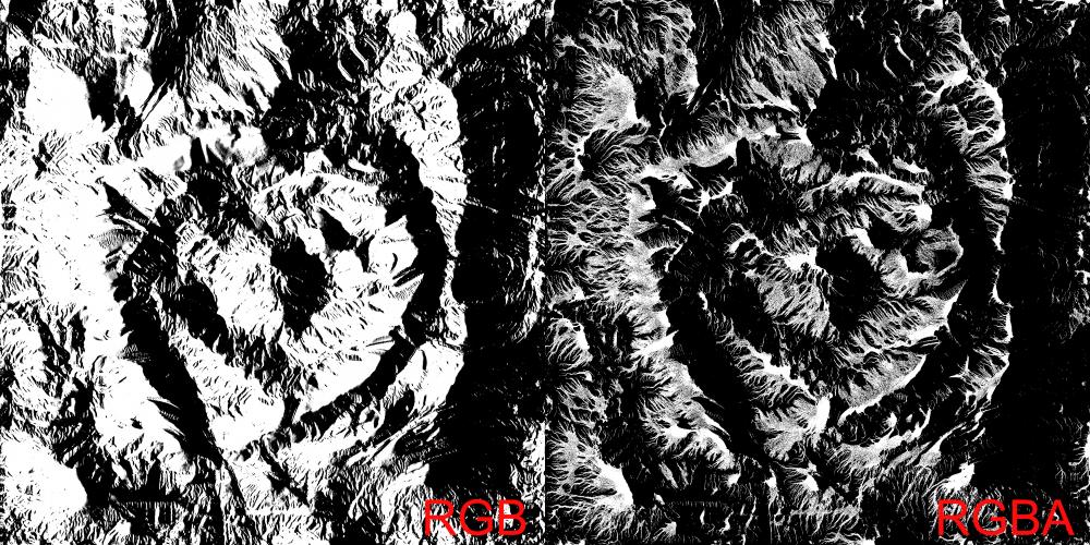
Hello, when exporting an image from the Heightfield Output node, when the .tga image is set to RGBA, the non-alpha channels are sorta polluted by the alpha. On the left, a direction mask, works fine, when exported into an 8 bit RGB tga. When I put the output node to RGBA and put something like sediments in the alpha, it affects the green channel (where the direction mask is stored), and there are no values of gray left, only pure black and white. Changing which layer is put in the alpha affects how the other three channels get polluted. Is there an option I'm missing? Is there a way to export an image in RGBA without getting unwanted results in the R, G and B channels? Thank you
-
It is possible to 'draw' sculptural details onto heightfields with zBrush-style alphas? It occurs to me this would be a great way to block out shapes & such, and yet I can't really think of any way to go about doing it, nor find any examples of anyone doing similar...
-
Hi all ! Do you know why the terrain erosion output varies drastically based on the initial grid spacing ? And how to overcome this issue ? I would like to get the overall shape obtained with a grid spacing of 0.5 (erosion, sediment, etc...) with a better level of details for close up scene. For this scene I've used the terrain shelf tool "Dunes" and let all the parameters as they are expect for grid spacing Thanks Alex
-
- grid spacing
- erosion
-
(and 1 more)
Tagged with:
-
The erosion node is the last on the network graph and every time I reopen the file everything starts recalculating. I've already frozen the erosion node on the frame I want, but I would like to store the result of the node on disc and reload it to continue from there. Any idea which node to use to cache the erosion? (up till now the terrain is a volume, not yet converted to polygons.
-
Hi everyone, I hope you all doing well. I am having a little problem with a shader I am building. Its a layered shader that I applied to some terrain. I am trying to add a global bump to get some better transition between materials. So far, I have a noise that is used as a mask to blend between materials and I also want to use the same mask to suggest that the underlying material is lower than the one above. How would you aproach this? I would be grateful for any help, all the best!
-
Is it possible in Houdini to export the terrain mesh in tiles?
-
Tried to export a heightfield of a terrain in greyscale using cop2net and sop import but I get individual elements (height, water, debris, sediment...). 1. How do I get the full terrain out of it? 2. How do I even get these individual elements out? You've guessed it, I'm new to Houdini.
-
Just the default terrain of Houdini default erosion, increased resolution to 4k, exported and I get consistently (3 times) pixelated lines in the heightfield, I can see them when I import in any software (World Machine...) I attach the file and the heightfield output. Do you get the same thing? terrain exports ugly pixelated lines.hiplc
-
Can I create or import a rectangular heightfield and export it as a rectangle not a square?
-
When I use heightfield output I get colour images. Heightfield images are greyscale values (white high, black low, greys in between). But why do I get coloured images when I export a png. How do I get the full terrain, because for now I only parts (height, sediment…) spread in colour channels, where is full the terrain in greyscale? like the whole thing?
-
Hi, It was briefly mentioned in the this post but I didn't really see a solution that worked for me. https://forums.odforce.net/topic/40201-workflow-for-creating-terrain/?tab=comments#comment-193820 I seem to struggle with getting detail in areas of terrain with a steep angle. Anything else I can do just fine. Any ideas on how to improve detail in areas with large/steep slopes? edit: erosion results seem absolutely horrible on steep slopes for me. It seems I get worse muddier results with new erosion node : ( see how much detail I have on the less steep areas. thanks
-
Hi, I have little agent insects on a rock, sitting on flat ledges. I'd like them to wander, while avoiding steep slopes of the terrain. Does anyone know the best method to go about this? (FYI I'm fairly new to crowd- I was imagining I'd need a pop wrangle to use a look-at function, which would estimate the possible future tilt, then apply an avoidance force.) Any help is much appreciated!
-
Workflow for creating terrain I am trying to create a realistic mountain terrain, but I can't find many resources on it. There is Alex Dracott's "Generating HeightField Terrain Textures" and "GDC 2017 - Houdini 16 Terrain Tools" but it leaves me with some questions that you guys maybe have the answer to. When I look at Alex Dracott, and other artists terrains, it looks like the vertical side of the mountains is texturered very nice, but how is this possible? The vertical sides of a hightfield will always have very low resolution, because the UV's a projected down on the surface in the Y direction. One though I had, was to create the UV's based on the quads that make up the heightfield, but this will involve some kind of remeshing, because the mesh also are scaled (Stretched). Extreme example of UV stretching <stretched_uvs.PNG> Another thing is the texturing. In Alex Dracott's video, he uses cop to create colored noise from masks and applies them back as textures, but what is the practice for texturing a big terrain with textures/materials? I have been playing around with substance painter, and projection, to "draw" materials, is there another way? Is it normal to export the heightfield mask and generate materials in a more procedural way via substance designer, for these big areas, or it more common to create the material from scratch without any masks in something like substance designer? And last, is it normal to create some kind of LOD system for such a project, or using UDIMS, to get the details we want when getting near curtain areas of the terrain? Maybe I am lost, and not even near what a real world workflow looks like, but I am sure that someone on the forum has experience with this.

